Fresh Groundwater Aquifers Under the Sea?
Yes! And there’s lots of it that could be pumped for water supply use on land
Prepared by Andrew Stone, Hydrogeologist (andrewstonewater(at)gmail.com)
An international team of scientists, led by Dr. Brandon Dugan, Hydrologic Science and Engineering Program, Colorado School of Mines, has been researching below the seabed for places where there are geological layers saturated with fresh water! To the right of this page is the logo of the research team, “Expedition 501 New England Shelf Hydrogeology.” The expedition is a joint collaboration between the International Ocean Drilling Programme and the US National Science Foundation. The work of the scientists is to find out where freshwater occurs offshore, quantify how much there is, work out when it got there and then (perhaps) work with coastal water managers to determine if there is an economical way to pump the freshwater onshore for water supply. This project is an exciting groundwater resources research endeavor encompassing the latest science and technology. Updates of all aspects of the project are reported online and should be of broad interest to all water managers and groundwater professionals.
At many places worldwide the locations of coastal submarine freshwater springs close to shore have been known for centuries. For these springs, the source of the freshwater bubbling up from the seabed is from aquifers recharged on land. However, the groundwater that is the focus of the Shelf Hydrology Project is too far offshore to be linked to any current land-sourced supply. The 501 research is building on previous studies, including geophysics surveys, and is focused on mapping the characteristics, dimensions and geometry of the fresh water in offshore aquifers and in determining the mechanisms by which freshwater came to be in continental shelf submarine aquifers.
During the Pleistocene ice ages, sea levels were at times over 300 feet lower than now. The continental shelf was then dry land, and aquifers could have been recharged by precipitation. Perhaps the shelf aquifers were recharged more recently with fresh meltwater under pressure beneath the ice during periods of glacial advances of ice sheets. Expedition 501 research may provide definitive answers.
Drilling in the 1970s provided evidence of freshwater in sediment layers below the New England shelf seabed. An exploratory borehole was drilled over 1,500 feet deep on Nantucket Island, Massachusetts in 1978, as part of the U.S. Geological Survey’s Stratigraphic Test Well project. This well found fresh water in in Pliocene-Pleistocene sand aquifers. In places the groundwater was less than 1,000 mg/L (seawater is 35,000 mg/L). The lenses of relatively fresh groundwater occurred in coarse grained sediments. The groundwater in layers of fine-grained silts and clays had higher salinities. An 850 ft exploration well drilled near Edgartown on Martha’s Vineyard Island in the late 1970s also showed groundwater of varying quality, with freshwater at 475 feet below sea level.
In 2025, Expedition 501 drilled a transect of three wells south of Nantucket. These were drilled from a lift boat through the shelf seabed to depths of 1,500 feet. Detailed logs of the geological layers and the chemistry of the groundwater were obtained during drilling. Over 2,500 feet of sediment cores were recovered for more detailed laboratory work on the hydraulic properties of the sediment, groundwater chemistry, microbiology and noble gas measurements. The cores are now stored at the Center for Marine Environmental Sciences at the University of Bremen (Germany) and all expedition data will be open access. The research results may have application that will assist assessment of the Earth’s many ocean shelf submarine aquifers with potential value as supply sources.
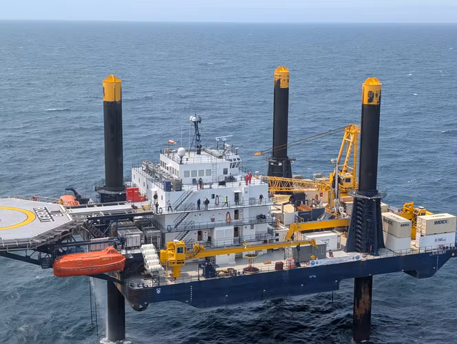
The 180 ft. long lift boat Robert is a self-elevating service vessel. Once in place, the boat is jacked up about 30 feet above high tide level and becomes a drilling platform. photo:
Mowat@ECORD_IODP3_NSFInformation for this Groundwater Picture of the Month was obtained from several internet sources.
Detailed information about offshore groundwater can be reached by browsing Expedition 501 New England Shelf Hydrogeology.
https://www.ecord.org/expedition501/ is the good initial source.
Bank Filtration – Nebraska Teachers Learn About Groundwater Supply
Is water from a well near a river actually groundwater?
Prepared by Andrew Stone, Hydrogeologist (andrewstonewater(at)gmail.com)
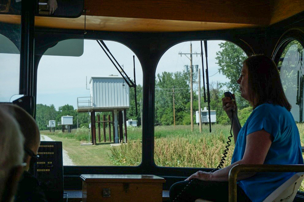
Photo credit: Andrew Stone
The photograph to the left shows water supply wells close to the Missouri River at Nebraska City, NE. The view from the bus was taken during an American Ground Water Trust field-trip training program for teachers. Water utility staff explain the engineering principle of bank filtration systems. Securing safe reliable water supply and having citizens educated about basic hydrology are both important objectives!
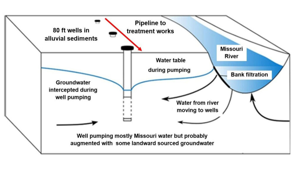
The wellheads of the riverbank wells are raised above flood level with their pumping equipment protected in the “sheds on stilts.” Flood waters typically have high turbidity and increased contaminants. Protecting wellheads is essential for the thousands of vertical wells or collector wells in alluvial sediments close to rivers. Some of the water pumped from riverbank wells may be groundwater that was naturally moving towards the river, but the bulk of water pumped from wells close to rivers is subsurface flow from the riverbed to the aquifer, induced when pumping lowers the water table.
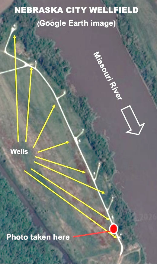
Riverbank filtration, sometimes called riparian groundwater, has been an accepted supply solution worldwide for millennia. Many high capacity systems installed in Europe in the 19th century are still in operation. The US has hundreds of large and small municipal systems that use bank filtration; for example, Louisville, KY, Des Moines, IA, Bismark, ND and Littleton, MA. Many riverbank systems use large diameter “Ranney” wells and some have horizontal well connections underneath the river. The eleven Nebraska City wells are vertical wells in alluvial sediments with a diameter of 18 inches and a depth of 85 feet.
Wells close to surface water are considered to have a risk of contaminants not usually found in true groundwater. The EPA has rules about the treatment of “groundwater under the influence of surface water.” However, water from alluvial wells near rivers requires much less treatment than water pumped directly from rivers. As water moves from the river to the well, chemical and biological processes in the aquifer remove pathogens, nitrogen, synthetic organic chemicals and pesticides resulting in treatment cost savings.
More Information
- RBFsim – A recent paper on Riverbank Filtration (RBF)
- Assessing RBF – Detailed technical information with over 100 references
- Whittman/Layne – Explanation of collector wells
“Tides They Are A-Changin’”,…Groundwater,…Ghost Forests
Prepared by Andrew Stone, Hydrogeologist (andrewstonewater(at)gmail.com)
“Changin” sea levels are impacting groundwater along coasts, estuaries and tidal rivers.
Ghost forests provide dramatic visible evidence of changes in subsurface water quality.
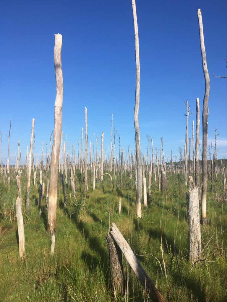
A “ghost forest” of dead trees refers to places where previously healthy trees have died because of increasing salinity in the root zone. The photograph (right) is from the Maryland coast where in places trees have died but remain standing. Rising sea levels can impact subsurface water quality by saline intrusion contamination. Some estimates show current global average sea level rise to be as much as 3mm/year, (about 1/8 of an inch). The dying of trees is a visible manifestation of future economic impacts on infrastructure that are likely to be much greater than the ecological loss of trees as ghost forests.
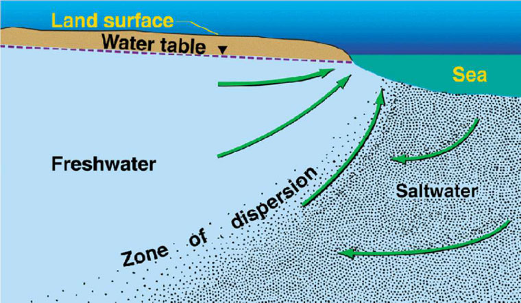
Basic physics and geology explain the intrusion process in coastal aquifers. The subsurface seaward movement of fresh groundwater can prevent saltwater from encroaching on coastal aquifers. The position of the saline/fresh interface in aquifers (zone of dispersion) involves a balance between gravity induced seaward groundwater flow and the sea level baseline. Coastal aquifers can occur in many geological environments provided there is enough interconnected permeability for hydraulic contact between land and offshore. The USGS diagram indicates that impacts of reduced groundwater flow and/or a rise in sea water level baseline will move the boundary zone between saltwater and non-saline water landward, causing saline contamination of groundwater or completely replacing what was preciously fresh groundwater. Storm surges and coastal flooding related to sea level rise can also exacerbate low-lying coastal salinity changes.
Over recent decades, sea levels worldwide have increased relative to the land. Why? A principal reason is rising global temperatures causing thermal expansion of seawater. Changing weather patterns are also increasing the rates of ice melting from the poles and mountain glaciers. In addition, decades of depletion of groundwater from aquifers has added to ocean volume. In some places, land subsidence or geological instability has locally accelerated the landward impacts of saline intrusion.
Some of the challenges for water-related infrastructure will require coastal communities to invest billions of dollars to mitigate the effects of increasing salinity of groundwater and rises in the level of water tables.
- Increasing salinity will result in the abandonment of wells for drinking water supply and irrigation.
- Even if salinity increases are small, there is increased risk of corrosion of pumps and equipment.
- Onsite septic systems could fail if rising groundwater levels impact leach fields in coastal homes.
- Saline seepage into municipal sewer systems could require new treatment processes or relocation.
- Landfills and low lying contaminated areas risk leachate generation from rising groundwater.
- Riparian saltwater intrusion from all tidal waters and any hydraulically connected drainage ditches
- and canals can bring salinity issues many miles inland from the coast.
A huge engineering and planning response is needed for sea level changes affecting millions of citizens in low lying coastal cities. Policy procrastination may turn out to be very costly. Ghost forests are just one “canary in the coal mine” that has already fallen off its perch. It is not a time-distant risk. Has anybody noticed?
Next time you are relaxing on an ocean beach give some thought to what is happening at the saline freshwater interface below the beach, and ask yourself – where is the “zone of dispersion” and is it moving inland?.
More Information
- Ground Water in Freshwater-Saltwater Environments of the Atlantic Coast, USGS https://pubs.usgs.gov/circ/2003/circ1262/
- Saltwater intrusion and sea level rise threatens U.S. rural coastal landscapes and communities. Link Scholarly article: 2024, O’Donnell et.al.
- Special Report on the Ocean and Cryosphere in a Changing Climate, IPCC https://www.ipcc.ch/srocc/ (Chapter 4)
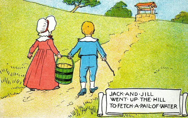
“Jack and Jill went up the hill to fetch a pail of water,
Jack fell down and broke his crown and Jill came tumbling after”
Prepared by Andrew Stone, Hydrogeologist (andrewstonewater(at)gmail.com)
What! – that first line is a great groundwater learning opportunity!
Have you ever realized that for many generations of young children the well-known Jack & Jill nursery rhyme, published in 1795, serves as their first introduction to groundwater! The rhyme provides four subliminal water resources messages:
1 Illustrations of the rhyme typically depicted a well with a rope and bucket. The message: there is water down the well, hidden in rocks and earth below ground level, (groundwater).
- To get the water out of the well there has to be some way to raise the water up to the surface.
In this case, a rope connected to a handle that works by muscle power. [Many 18th and 19th century illustrations show Jack & Jill as young children. However, even if they could reach the handle, lifting the bucket up the well is probably more than small children can manage!]

3.Once out of the well and into the bucket, the real work begins because the (heavy) water has to be carried (without spilling) from the well to the home. [For many, but not all, communities worldwide, pumps have transformed the chore of getting groundwater out of the well.]
4.Two-person teamwork may be needed when carrying a heavy bucket to ensure that the precious water arrives safely. [Pipelines have revolutionized “fetching water” although UNICEF reports that 2.1 billion people worldwide do not have access to safely managed water. Children often have “fetching” responsibility.]
The first line of the rhyme has relevance from a water perspective. There are also interesting backstories about the rhyme’s origins and meaning. The names Jack & Jill were typically used in the 16th century as generic names for a man and a woman or boy and girl. Shakespeare uses the names in the plays, A Midsummer Night’s Dream and Love’s Labor’s Lost.
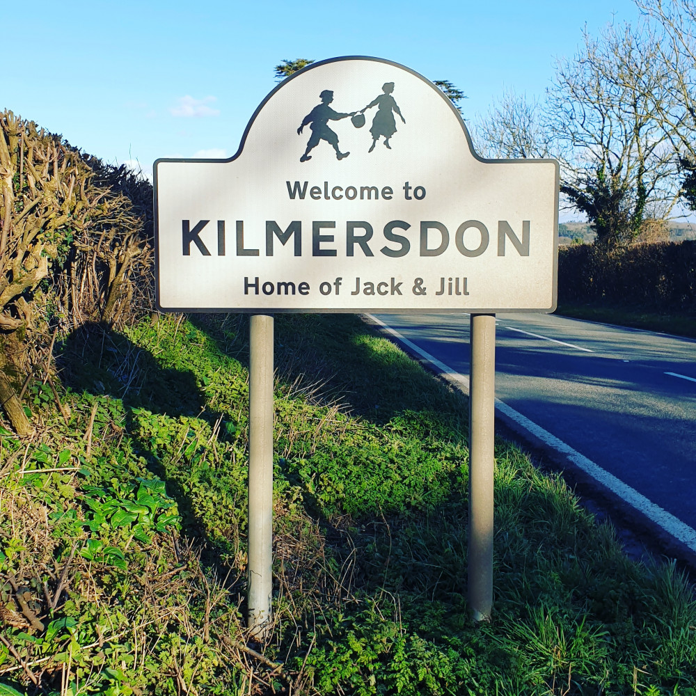
The village Kilmersdon in western England claims to be the place where the rhyme originated. The village has a road sign claiming “ownership.” A local historian, Martin Horler, researched the folklore and gives a date of 1645, when according to legend, Jack and Jill (who are teenagers) climb a local hill called Badstone, and in a quarry at the top, a boulder falls and crushes Jack (broke his crown) and two days later the disaster is compounded when Jill dies in childbirth (came tumbling after). This disaster, (if true and the date accurate!) took place 150 years before the first known publication of the nursery rhyme, giving plenty of time for the words retelling the tragedy to be transformed. The water well origins of the story received supporting evidence in 1999 when an old well was discovered on the top of Badstone Hill in Kilmersdon. This gave the village “proof” that their claim to the origins of Jack & Jill was correct. Archaeologist Dr. Peter Addyman confirmed the 35 foot deep well’s 16th century origins and Kilmersdon doubled down on their claim to be the home of the Jack & Jill story.
A French claim to the rhyme’s origins is that the rhyme, (Jack et Jill la colline ont monté), originates from France’s Revolution. The words describe the demise of King Louis XVI who was guillotined in1793 (broke his crown) and his wife Marie Antoinette, who was beheaded the following year (came tumbling after).
Yet another suggestion of the rhyme’s meaning is that is satirizes England’s King Charles I, who in the 17th century tried to raise money by reducing (“tumbling down”) the volume of a Jack (1/8 pint), of beer or wine while keeping the same tax. The size reduction the gill (1/4 pint) would then come “tumbling after,” (Jack & Gill)
As is the case with many nursery rhymes, the origins of tragedy: “rocks crushing heads” “kings and queens beheaded” “raising taxes on drinks” may refer to real occurrences that are retold in a gentler form.
More Information
- The true meaning of dozens of nursery rhymes is documented and speculated in many publications, for example:
the book “Pop Goes the Weasel, The Secret Meaning of Nursery Rhymes” by Albert Jack, 2009, Penguin Books. - For information about Kilmersdon’s claim to be the “home of Jack & Jill”, go to Wikipedia or any search engine.
- Visit UNICEF for information about global drinking water challenges – https://www.unicef.org/wash/water-scarcity
Water from Owens Valley for Los Angeles Water Supply Includes Groundwater! Tribes Want it Back!
Prepared by Andrew Stone, Hydrogeologist (andrewstonewater(at)gmail.com)
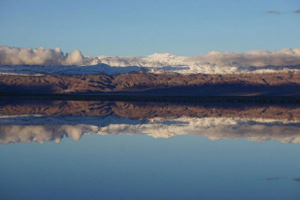
This Owens Lake picture has a groundwater backstory! | photo credit: Andrew Stone
Looks are deceiving! The placid reflections in this photograph of Owens Valley Lake disguise the realities of the negative economic, social and ecological results of “forced” water transfers from Mono Basin and Owens Valley. It is not generally recognized that groundwater is a significant component of the “stolen” water. Since the early 20th century, the Owens Valley and later, the Mono Lake hydrologic system have been systematically commandeered, and their streams, lakes and wetland ecosystems east of the Sierras have been continually deprived of adequate water.
The Owens River Valley is on the northeastern foothills of the Sierra Nevada mountains. Geologic faults and volcanic activity formed the Mono Lake basin over the last 5 million years. [LINK]
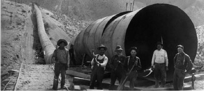
For the last 100+ years vast quantities of water have been diverted via pipelines, siphons, canals and aqueducts for water supply 200+ miles away in Los Angeles. Groundwater contributes to the flow of the diverted headwater streams and in addition, groundwater in the Owens Valley hydrologic system is also accessed by wells owned by the City of Los Angeles. In the 1940s, tunnels were constructed north from Owens Valley to the Mono Basin and 1970 a second aqueduct was built that doubled the capacity to divert water south to LA.
An October 18th , 2025, article by the Mojave Desert, journalist Ian James, published in the Los Angeles Times, reports that leaders of the Native tribes in the Owens Valley are asking the city to take less water because current groundwater pumping has dried up the few existing springs and negatively affected meadow vegetation. According to the L A Times article, the Owens Valley “once had so many springs, streams and wetlands that the Paiute and Shoshone people called their homeland Payahuunadü, (the land of flowing water.) Today, tribal members say LA’s extensive use of water has transformed the landscape, desiccating many springs and meadows, killing native grasses and altering the ecosystem.”
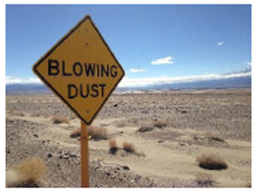
Since 1941 when flow to Mono Lake was diverted, the lake’s surface area has been reduced by over 60%, the lake level has dropped by 45 feet, and the lake salinity has doubled. In the 1970s and 1980s, groundwater pumping in Owens Valley also impacted groundwater dependent natural vegetation north of Owens Lake. Lowered lake levels have exposed dry lake beds at Mono Lake and Owens Valley Lake. Wind blowing the dust from the exposed lake beds causes toxic air quality challenges. Following a 1979 lawsuit by Inyo County and environmental organizations, the City of LA has been required to install dust suppression systems that spray water on the dry lakebed.
It seems ironic that some of the groundwater from wells, and rerouted flow from streams, that formerly maintained vibrant Owens Valley ecosystems, now has to be used for suppressing dust caused by diverting water to Los Angeles.
See the links below for much more information about this hydrological engineering controversy.
The information in this article shows just the tip of a very big (125 year old hydrological & political) iceberg!
Original aqueduct construction: https://waterandpower.org/museum/Construction_of_the_LA_Aqueduct.html
Mono Craters Tunnel: https://www.monolake.org/today/groundwater-exports-benefit-los-angeles-impact-mono-lake/
1970 Aqueduct: https://waterandpower.org/museum/A_Second_Aqueduct.html Toxic Dust: https://www.plantsciences.ucdavis.edu/news/eviner-nas-owens
2025 LA Times report: Ian James reports for the Los Angeles Times October 18, 2025, with photography by Carlin Stiehl
LA Dept of Water & Power – annual report: https://www.ladwp.com/sites/default/files/2024-06/2024%20Final%20Owens%20Valley%20Report.pdf
Picture of the month prepared by Andrew Stone, Hydrogeologist, (andrewstone @ gmail.com)
THREE ROCK TYPES IN ONE PHOTOGRAPH
1. Dolerite (igneous – intrusive volcanic)
2. Mudstone (sedimentary)
3. Where the dolerite as molten magma “cooked” the sedimentary rock, (metamorphic)

Photo Credit: Andrew Stone
The sedimentary layers in the photograph are in the Beaufort Group of the Karoo Sedimentary Basin in South Africa and were deposited about 250 million years ago. The igneous dolerite dike (1.) resulted from volcanic activity about 180 million years ago. Dikes can serve as barriers or as conduits for groundwater movement. Geophysical techniques are typically used to help characterize the geometry of subsurface geology in areas where dykes and sills occur.
Sill or Dike?
A sill of igneous rock does not cut across preexisting rock beds and is described as concordant. An igneous dike (as shown in the photograph) is described as discordant and does cut across the layers of older rocks.
For links and more information:
Collier Consulting is currently looking to expand the company’s geophysical team in the Denver, Colorado area. We are accepting applications to fill a number of job openings for senior level geophysicists, junior level geophysicists, field technicians, and office support staff. If you are interested in applying for any one of these positions, please contact us at (720) 487-9200 or submit your resume to info@collierconsulting.com.