

Irrigation, Declining Groundwater — San Luis Valley, Colorado
Regional drought, less winter snowpack, less snow to melt, less aquifer recharge, aquifer depletion, groundwater quality deterioration, water rights complexity, pumping management dilemmas!
Prepared by Andrew Stone, Hydrogeologist (andrewstonewater(at)gmail.com)
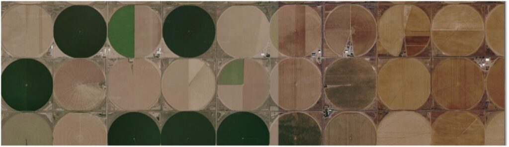
In many parts of the world there are water management challenges related to climate change and groundwater pumping in excess of recharge. The San Luis Valley in Colorado is one such area. Other states, such as California, Nebraska and Arizona have irrigation areas with similar challenges of supply & demand mismatch.
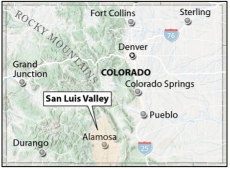
The San Luis Valley with an average elevation of 7,000ft above sea level has a cold desert climate with annual precipitation below 8 inches. Prior to settlers arriving in the Valley in the mid-19th century the Kapota band of Ute Indians lived in the Valley. Early settlers recognized irrigation potential and developed stream-fed systems for agriculture. By the 1880s, water conflicts among settlers were occurring and in 1888 there was a General Adjudication of water rights. By the end of the 19th century all the surface water rights had been appropriated. The 8,000 square mile Valley has two major groundwater aquifer systems that have been developed for productive commercial agriculture. By the 21st century declining groundwater levels were causing increased challenges for water management. In this third decade of the century, the declining water availability for irrigation has become more dire.
Geologically, the San Luis Valley is a downfaulted structural basin. There are confined and unconfined aquifers in sediments filling the basin. Between five and one milion years ago the valley contained Ancient Lake Alamosa. Thick layers of sand, gravel and clays developed in the lakebed, and those sedimentary deposits, now identified as the Alamosa Formation, contribute to the hydrogeological complexity of parts of the confined aquifers. The upper unconfined aquifers are separated from the lower confined aquifers by these clay layers. Streams flowing from the surrounding Sangre de Cristo and San Juan Mountains are the principal source of groundwater recharge with spring snowmelt sustaining the streams. Groundwater in the confined aquifers is under pressure, but it was only in the early years that there was artesian flow that reached the surface. tion.
The Rio Grande River flows through the Valley, and diversion ditches have long been a source for irrigation. Groundwater naturally helped sustain river flow, and excess irrigation water from inefficient flood irrigation helped recharge the aquifers. In the 1950’s rural electrification programs and high capacity pumps increased pumping and decreased the volume of groundwater. A 1969 state law required the State Engineer to integrate administration of groundwater and surface water rights to protect senior water right holders. As a response to declining groundwater levels, in 1972 the state declared a moratorium on new wells in the artesian aquifer followed by a 1981 moratorium for new wells in the unconfined aquifer. In 2004, a law was passed (SB04-222) ordering that aquifers in the Valley must be managed for sustainability. An added complexity is that the Rio Grande River is subject to an interstate water sharing compact.
The establishment of local control via groundwater sub-districts was a strategy of SB04-222 designed to achieve agreements on reducing Valley pumping by 20%. Many areas do not have detailed records of past irrigation use. Groundwater pumping metering only began in 2009, and groundwater aquifer models have been used to characterize the aquifer dynamics and quantify needed pumping reductions. Protecting water rights and also maintaining faming viability has led to legal issues among landowners, districts and the state. There are ongoing endeavors to take land out of production to achieve sustainability. “Buy and dry” efforts have made use of use federal programs such as the Conservation Reserve Enhancement Program. Provided there are funds available, recent pioneering initiatives to retire crop circle irrigation by conservation easements may help towards sustainability.

Heavy metals, such as arsenic, uranium, tungsten, and manganese, occur naturally in Valley aquifer sediments. Drilling deeper wells closer to bedrock where heavy metal concentrations may be higher, and having less recharge water available to dilute contaminants has resulted in elevated levels in some wells. Arsenic in irrigation water can stunt crop growth but the main concerns are the negative socioeconomic impacts of contamination in private wells where levels exceed health thresholds.
Worldwide there are groundwater problems because of over pumping and climate change impacts on recharge. San Luis Valley is a representative case study of political and economic challenges resulting from developing groundwater beyond sustainability. Using good science to quantify the geometry and hydraulic characteristics of aquifers is a perquisite for resource management. Achieving agreement among groundwater professionals, landowners, irrigation districts, local government and state regulators about cause and effect, and implementing equable effective solutions, is a Herculean challenge that should be front and center of water policy.
BIG PIVOS: 21st Century Realities Hit San Luis Valley Agriculture | San Luis Valley background
San Luis Valley Drinking Water Heavy Metals Explained – Circle of Blue
Easements for Aquifer Rcover in the San Luis Valley
Ash Meadows, Nevada — A Unique Oasis in the Desert
Complex hydrogeology. Flow system with discharge at Death Valley. Endangered pupfish dependent on springflow. Threatened habitat. Water quality threats from development, nuclear test site and lithium mining.
Prepared by Andrew Stone, Hydrogeologist (andrewstonewater(at)gmail.com)

Ash Meadows is an area in the Amargosa Desert in southwest Nevada with an ecosystem sustained by groundwater. Often described as an oasis in the desert, springs at Ash Meadows are outflows from subsurface water “plumbing” which are part of the Death Valley Regional Flow System. Geologically, Ash Meadows is in the tectonic Basin & Range system of the western US. Earth movements stretching the Earth’s crust in the early Cenozoic Era (60 million years ago) resulted in geological faults producing a series of grabens (basins) and horsts (ranges) between eastern Utah and California.
The groundwater that emerges at Ash Meadows originates as snowmelt from Spring Mountains to the east. At Ash Meadows there are 30 separate springs and seeps with a combined flow of about 10,000 gallons per minute. Groundwater flowing in a southwesterly direction in limestone and dolomite carbonate rocks reaches the surface because of geological fault systems that act as both conduits and barriers to flow. The geological cross section below (modified from US Geological Survey Report, 994079) shows a simplified concept of the springs’ “plumbing system.” The springs were once part of a much larger system of lakes and streams that started to dry up about eleven thousand years ago when the regional climate changed, isolating the fish population.

The endemic Ash Meadows Amargosa Pupfish is found only in the spring-fed streams and pools in the Ash Meadows National Wildlife Refuge. The spring systems are of great ecological significance. The springs include the Devil’s Hole, declared a National Monument in 1952. The Devils Hole Pupfish (Cyprinodon diabolis) is a one inch long critically endangered species that only lives in the upper part of the 400 foot deep Devils Hole cavern. The spring system has been threatened by agricultural development by settlers in the 19th and 20th centuries, irrigation pumping in the 1970s, proposed housing development in the 1980s and more recently, plans for an open pit lithium mine on the margins of the Ash Meadows National Wildlife Refuge. In addition to potential hydrological impacts from climate change, there is a possible future groundwater contamination risk from the upgradient nuclear test site 50 miles away.
For more information and links to videos and websites about the interesting Ash Meadows hydrogeological/ecological system and the politics of threats and protection, just put keywords Ash Meadows Springs or Devils Hole Pupfish into your browser. USGS report 99-4079 is a good source for hydrogeological information.
Fresh Groundwater Aquifers Under Utah’s Great Salt Lake?
Recent research has established that there could be vast freshwater resources
Prepared by Andrew Stone, Hydrogeologist (andrewstonewater(at)gmail.com)
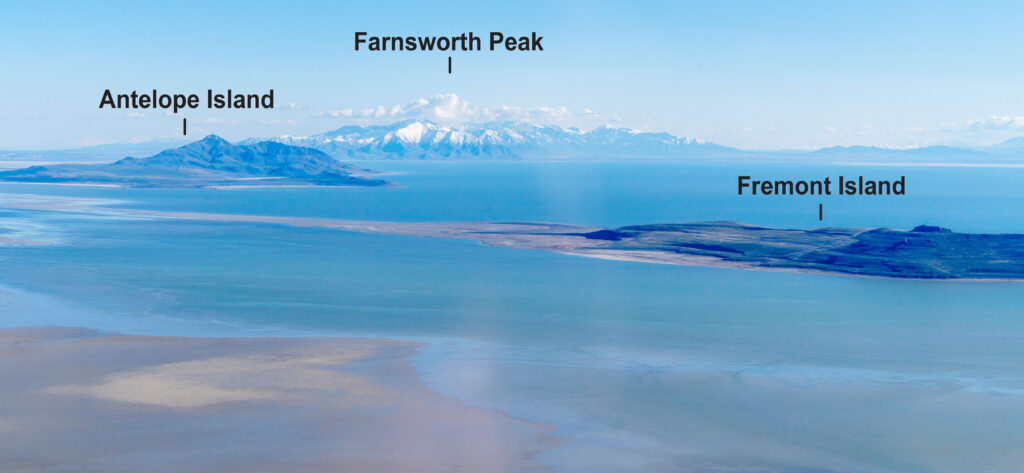
Antelope Island, left in this photograph.] Photo credit: EcoFlight
The 1,500 mile2 Great Salt Lake (GSL) in Utah is the largest endorheic lake (no external drainage) in North America. Geologically, GSL is on the eastern margin of the Basin and Range Province that extends west to California. The Great Basin comprises a series of north-south-trending mountain ranges separated by downfaulted deep sediment-filled basins. In endorheic lakes with no outflowing drainage and high evaporation, water becomes progressively salty.
The GSL today is a small remnant of the 20,000 miles2 Lake Bonneville that existed 15,000 years ago. Over the last 150 years the depth of the shallow GSL has varied by as much as 22 feet. In addition to direct rainfall, the input of water to GSL comes from inflow from rivers and seepage from lake margin groundwater.
Recent electromagnetic geophysics surveys of the Farmington Bay Area of the GSL by the University of Utah Department of Geology and Geophysics have provided evidence that there could be a considerable extent of freshwater aquifers beneath the GSL. (See report links below). One of the geophysical methods used was airborne electromagnetic (AEM). This measures the electrical resistivity of geology beneath the lake by transmitting electromagnetic fields from instruments flown over the lake by helicopter. Responses to the electromagnetic signals from lake sediments saturated with salt water indicate thin, highly conductive layers beneath the hypersaline lake water. Beneath these layers, the instruments identified layers with more resistant responses to the signals. The differing resistance indicates that the deeper sediments are saturated with fresher water than in layers closer to the lakebed. Freshwater-saturated sediments beneath the lake layer have also been confirmed by water salinity and chemistry measurements from test wells.
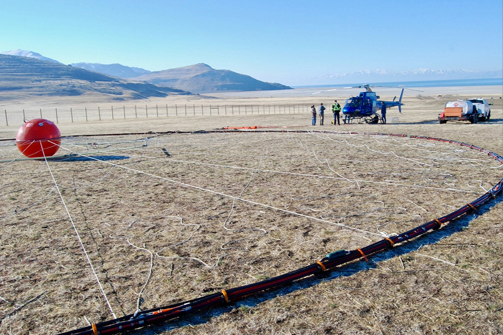
(Feb 2025) Photo: Brian Maffly, University of Utah
Geophysics equipment for airborne data-gathering Farmington Bay, UT (Feb 2025) Photo credit: Brian Maffly, University of Utah Geophysics technology can help delineate the geometry, extent, and internal structure of the geology beneath the lake. Previous geological studies have shown that in places there are depths of up to 9,000 feet of sediments below the lake overlying down-faulted basement rocks. If salty sediments over the whole lake are restricted to thin layers in near-surface zones, then the vast volume of sedimentary and volcanic rocks below the lake could potentially be freshwater-saturated.
What are the water management implications in the arid water-short western states of a possible vast GSL aquifer system with freshwater? If there are proven freshwater reserves, there will be economic and environmental issues that will require creative engineering solutions for any large scale water supply development. The State of Utah owns the GSL and presumably any development of water resources would be the state’s responsibility.
However, Farmington Bay is a relatively small area of the GSL and before the current research results can be extrapolated to the whole GSL Basin there needs to be extensive hydrogeological investigation to characterize the basin’s water resource potential. Geophysics is likely to be a key component of more comprehensive research to reveal the geometry and stratigraphy of the basin’s geology. Assessing the potential for groundwater development will also require characterization of recharge and flow systems and modeling of the basin’s hydrogeology and hydrochemistry.
There are recent research findings of extensive freshwater aquifers miles offshore below the seabed on New England’s continental shelf. There are confirmed freshwater aquifers occurring in the Mojave Desert that have been proposed as an augmentation source for Southern California water supply. Results from the Farmington Bay research of the GSL Basin’s freshwater potential would seem to justify investing in more hydrogeological research under the GSL.
Utah Geological Survey website (https://geology.utah.gov/) has many reports on the GSL. Reports on the subject of this article (GSL groundwater) are : Scientific Reports – Open Access, February 2026 (Principal reference) Journal of Hydrology April 2026
Fresh Groundwater Aquifers Under the Sea?
Yes! And there’s lots of it that could be pumped for water supply use on land
Prepared by Andrew Stone, Hydrogeologist (andrewstonewater(at)gmail.com)
An international team of scientists, led by Dr. Brandon Dugan, Hydrologic Science and Engineering Program, Colorado School of Mines, has been researching below the seabed for places where there are geological layers saturated with fresh water! To the right of this page is the logo of the research team, “Expedition 501 New England Shelf Hydrogeology.” The expedition is a joint collaboration between the International Ocean Drilling Programme and the US National Science Foundation. The work of the scientists is to find out where freshwater occurs offshore, quantify how much there is, work out when it got there and then (perhaps) work with coastal water managers to determine if there is an economical way to pump the freshwater onshore for water supply. This project is an exciting groundwater resources research endeavor encompassing the latest science and technology. Updates of all aspects of the project are reported online and should be of broad interest to all water managers and groundwater professionals.
At many places worldwide the locations of coastal submarine freshwater springs close to shore have been known for centuries. For these springs, the source of the freshwater bubbling up from the seabed is from aquifers recharged on land. However, the groundwater that is the focus of the Shelf Hydrology Project is too far offshore to be linked to any current land-sourced supply. The 501 research is building on previous studies, including geophysics surveys, and is focused on mapping the characteristics, dimensions and geometry of the fresh water in offshore aquifers and in determining the mechanisms by which freshwater came to be in continental shelf submarine aquifers.
During the Pleistocene ice ages, sea levels were at times over 300 feet lower than now. The continental shelf was then dry land, and aquifers could have been recharged by precipitation. Perhaps the shelf aquifers were recharged more recently with fresh meltwater under pressure beneath the ice during periods of glacial advances of ice sheets. Expedition 501 research may provide definitive answers.
Drilling in the 1970s provided evidence of freshwater in sediment layers below the New England shelf seabed. An exploratory borehole was drilled over 1,500 feet deep on Nantucket Island, Massachusetts in 1978, as part of the U.S. Geological Survey’s Stratigraphic Test Well project. This well found fresh water in in Pliocene-Pleistocene sand aquifers. In places the groundwater was less than 1,000 mg/L (seawater is 35,000 mg/L). The lenses of relatively fresh groundwater occurred in coarse grained sediments. The groundwater in layers of fine-grained silts and clays had higher salinities. An 850 ft exploration well drilled near Edgartown on Martha’s Vineyard Island in the late 1970s also showed groundwater of varying quality, with freshwater at 475 feet below sea level.
In 2025, Expedition 501 drilled a transect of three wells south of Nantucket. These were drilled from a lift boat through the shelf seabed to depths of 1,500 feet. Detailed logs of the geological layers and the chemistry of the groundwater were obtained during drilling. Over 2,500 feet of sediment cores were recovered for more detailed laboratory work on the hydraulic properties of the sediment, groundwater chemistry, microbiology and noble gas measurements. The cores are now stored at the Center for Marine Environmental Sciences at the University of Bremen (Germany) and all expedition data will be open access. The research results may have application that will assist assessment of the Earth’s many ocean shelf submarine aquifers with potential value as supply sources.
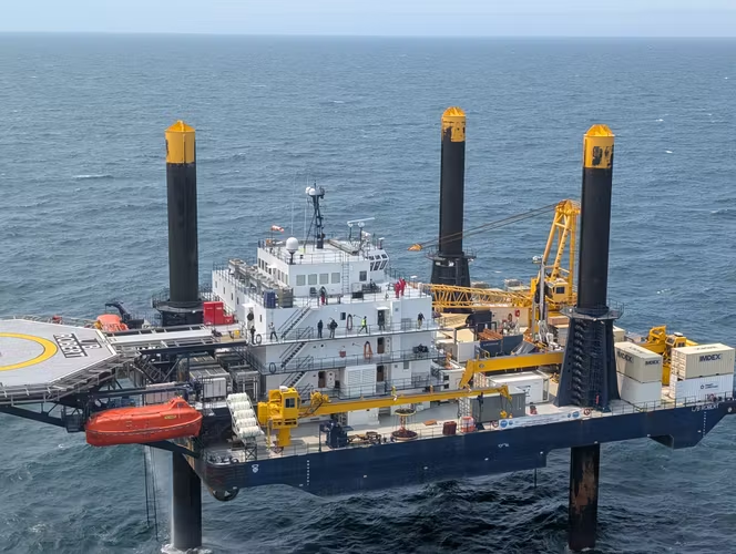
The 180 ft. long lift boat Robert is a self-elevating service vessel. Once in place, the boat is jacked up about 30 feet above high tide level and becomes a drilling platform. photo:
Mowat@ECORD_IODP3_NSFInformation for this Groundwater Picture of the Month was obtained from several internet sources.
Detailed information about offshore groundwater can be reached by browsing Expedition 501 New England Shelf Hydrogeology.
https://www.ecord.org/expedition501/ is the good initial source.