Collier is a leader in the application of shallow high-resolution 2-D and 3-D reflection surveys for small and medium sized petroleum exploration projects. We have specialized expertise in planning, logistical management, and field operations in environmentally sensitive and challenging terrain and sensitive regions. We design, plan, and perform seismic data acquisition on a contract basis or as a turnkey service including data processing and interpretation to map; stratigraphy, oil and gas deposits, coal bed methane (CBM) formations, coal seams, and other economic minerals. We are leaders in the use of full wave form acquisition and processing of reflection and refraction tomography data to map deep karst features and fracture detection.
We are leaders in bringing attribute processing to the shallow reflection market and have proprietary processing strings to map fine scale faulting, karst, and fractures. We work in urban environments, mountainous terrain, desert environments, wetland, jungle regions, and other difficult environments. Our seismic surveys are designed to minimize impact on the environment by using portable instruments, wireless acquisition systems, small seismic crews, and seismic sources with a small environmental footprint.
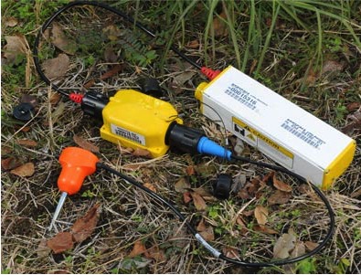
Collier uses only the most modern seismic survey equipment, and also has the ability to customize and integrate equipment to enhance data quality and meet special field operations and environmental conditions. Prior to conducting the planned survey, all seismic equipment is tested to confirm performance according to manufacturer specifications. Initial QA/QC data may be acquired periodically to make sure the survey parameters will produce the desired results. In-field pre-processing analysis is often performed (e.g. refraction picks, generation of time-distance curves, velocity analysis, and/or brute stacks) to provide initial interpretation and field QA/QC analysis.
Accelerated Impact Seismic Energy Source Operations
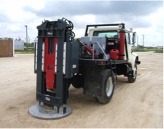 Where applicable, Collier uses the Nitrogen Gas-Charged Accelerated Impact Seismic Energy Source system to acquire seismic data where other conventional energy source systems cannot be used. These energy source systems are high powered, environmentally friendly impact seismic sources that can be used with almost any type of modern seismograph system, and can be used for a variety of 2-D and 3-D seismic programs. These seismic sources can work in many areas where explosive and vibratory seismic sources cannot, either because of regulations, or because of the risk of damage to underground pipes, utility lines, surface structures, and wildlife habitats. Survey applications using the accelerated impact source include shallow and deep refraction surveys, 2-D and 3-D seismic reflection surveys, Vertical Seismic Profiling (VSP), and downhole seismic or LVL surveys. On 3-D seismic surveys requiring QC and (x,y,z) source location & monitoring systems is achieved using high precision GPS/DGPS mobile receivers.
Collier also employs the use of explosives for 2-D and 3-D seismic surveys in areas where permitted. Seismic surveys using explosives are performed and managed in accordance with the International Association of Geophysical Contractors (IAGC) Guidelines and Safety Programs, with site specific plans of execution guidelines developed by Collier to minimize drilling and seismic operation impact on the environment.
Seismic Survey Special Operations
Seismic surveys located in difficult terrain and regions that are environmentally sensitive require specialized seismic instruments, drilling and operations support equipment, and field logistics management. As each survey site is unique in terms of these requirements, Collier emphasizes detailed advance project planning consulting services to develop operations plans that will minimize impact on the environment, and maximize seismic coverage and overall data quality.
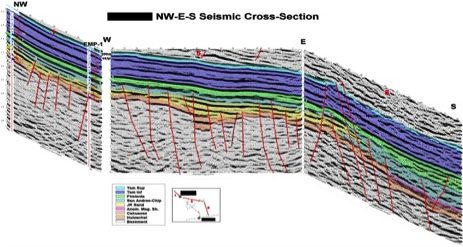
2-D and 3-D Seismic Processing and Interpretation
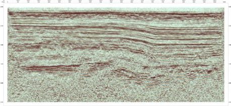
Seismic data processing capabilities include in-field 2-D processing for QA/QC purposes, and final full 2-D and 3-D data processing. Programs used for in-field QA/QC seismic processing are ProMax or RadExPro. The Vista™ 2-D and 3-D seismic processing programs are used for full final in-house data processing. For seismic surveys conducted in areas that exhibit complex near surface refraction and reflection velocity-statics problems, GSS uses the joint travel-time and full waveform inversion 2-D and 3-D TomoPlus™ tomography processing program. Application of TomoPlus tomography processing correctly defines complex near surface statics and velocity fields to provide improved deep seismic imaging.