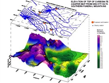
Gravity methods measure the change in the earth’s gravitational field caused by variations in the density of the subsurface. Gravity surveys can be used to detect and map buried structures such as faults, voids, bedrock topography, and basin geometry. The data can be process to determine the size, depth, shape, and composition of various targets.
Typical Applications of Magnetic Methods
- Karst features
- Voids & tunnels
- Bedrock valleys & paleo channels
- Faults & other geologic structure
- Basin geometry
- Petroleum exploration
- Natural resources exploration