Offices in multiple states, jobs that travel the world, and a team of professionals across the board. Check out our open positions on our hiring page below!

Picture of the month prepared by Andrew Stone, Hydrogeologist, andrewstone@gmail.com
GOLDEN GATE PARK, SAN FRANCISCO, WIND PUMP
Ah! … This is NOT a windmill. Simple explanation is that this is a wind operated pump and not a wind operated mill. OK? Likewise, it is wind turbines, not windmills that are contributing to the national electricity grid.
Photo Credit: Andrew Stone
The origins of the San Francisco wind pumps (there were two) began in the late 1800s when irrigation water was needed or the west end of the 1,000-acre Golden Gate Park. Initially, water was supplied by the Spring Valley Water Company, but the City of San Francisco realized that pumping their own groundwater from the old sand-dune aquifer beneath the park was a much less expensive option. The first windpump was completed in 1903 and produced 2,000 gallons an hour. A second wind pump was constructed in 1908 with a pumping capacity of 40,000 gallons per hour. The George E. Dow Pumping Company installed the pump system(photo 1). Together, the two windmills pumped up to 1.5 million gallons a day to reservoirs in the park(photo 2). However, by 1913 the wind driven pumps were replaced by electric pumps. After many decades of disrepair, action by conservation groups has led to restoration of both windmills as historic monuments. (Few people know when they were built, what they were built for or are likely to ever call them by their correct functional name of windpump!)
WIND PUMPS (WINDMILLS) AT GOLDEN GATE PARK – SAN FRANCISCO
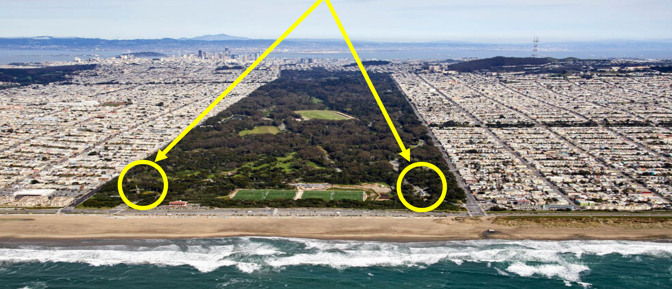
Photo Source: http://assets.ltkcontent.com/images/931020/golden-gate-park_3b74c0a0aa.jpg
For links and more information
Windmill Power for Golden Gate Park – 1914
Historical San Francisco News Update from 2000
Every month Collier sends out employees all over to several conferences, see below to find out if you can catch us at any!
Georgia Transportation Summit – December 3rd in Athens, GA
USACE LRD Industry Day – December 4th in Cincinnati, OH
NGWA Groundwater Week – December 10th in Las Vegas, NV
SAME JAX Industry Day – December 10th in Jacksonville, FL
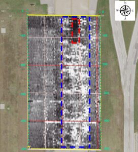
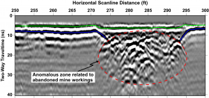
Ground Penetrating Radar (GPR) is a non-destructive tool that uses radar pulses to image the subsurface. Here are just some key applications:
▪ Utility Mapping
▪ Concrete Inspection
▪ Environmental Studies
▪ Archaeological Digs
▪ Transportation
▪ Geological Mapping
▪ Geologic Hazards
▪ Forensics
▪ Landfill Characterization
▪ And many more!
GPR’s versatility makes it useful across multiple applications.

Picture of the month prepared by Andrew Stone, Hydrogeologist, (andrewstone @ gmail.com)
THREE ROCK TYPES IN ONE PHOTOGRAPH
1. Dolerite (igneous – intrusive volcanic)
2. Mudstone (sedimentary)
3. Where the dolerite as molten magma “cooked” the sedimentary rock, (metamorphic)

Photo Credit: Andrew Stone
The sedimentary layers in the photograph are in the Beaufort Group of the Karoo Sedimentary Basin in South Africa and were deposited about 250 million years ago. The igneous dolerite dike (1.) resulted from volcanic activity about 180 million years ago. Dikes can serve as barriers or as conduits for groundwater movement. Geophysical techniques are typically used to help characterize the geometry of subsurface geology in areas where dykes and sills occur.
Sill or Dike?
A sill of igneous rock does not cut across preexisting rock beds and is described as concordant. An igneous dike (as shown in the photograph) is described as discordant and does cut across the layers of older rocks.
For links and more information:
Every month Collier sends out employees all over to several conferences, see below to find out if you can catch us at any!
Rocky Mountain Geo-Conference – November 1st in Westminster, CO
SEG 4D Forum – November 4-6 in Galveston, TX
Geology Days Conference – November 11-13 in Saratoga Springs, NY
SAME Dam & Levee Resilience Conference – November 12-14 in Davis, CA
Southeastern Transportation Geotechnical Engineering Conference – November 18-21 in Baton Rouge, LA
Oklahoma Governor’s Water Conference – November 19-20 in Norman, OK
SAME Federal Small Business Conference – November 20-22 in New Orleans, LA
The year 2023 is a special one for Collier – it marks our 25th anniversary!
In 1998, Hughbert Collier decided to leave academia and pursue consulting full time. Thus, Hughbert and Gail founded Collier Consulting, Inc. The company had humble beginnings as Hughbert and Gail officed out of their home kitchen. The first employees were some of Hughbert’s recent students from Tarleton State University. These few employees were officed our of an adjacent carriage house and would make frequent trips in and out of the house. Some projects were even completed using the dining room table.
In 2006, Collier Consulting moved out of the kitchen into an office building. With sustained growth the company steadily outgrew that building. In 2013, Hughbert and Gail purchased The Stephenville Empire Tribune’s (town newspaper) building and moved in. In the period from 2016 to 2022, Collier Consulting experienced some it most significant growth. The company doubled in size from approximately 20 to over 50 employees. The Collier Family started a sister company, Collier Geophysics, in 2018. Since then, they have expanded out of Texas and now have offices in Colorado, Georgia, Massachusetts, North Carolina, Tennessee, and Wisconsin.
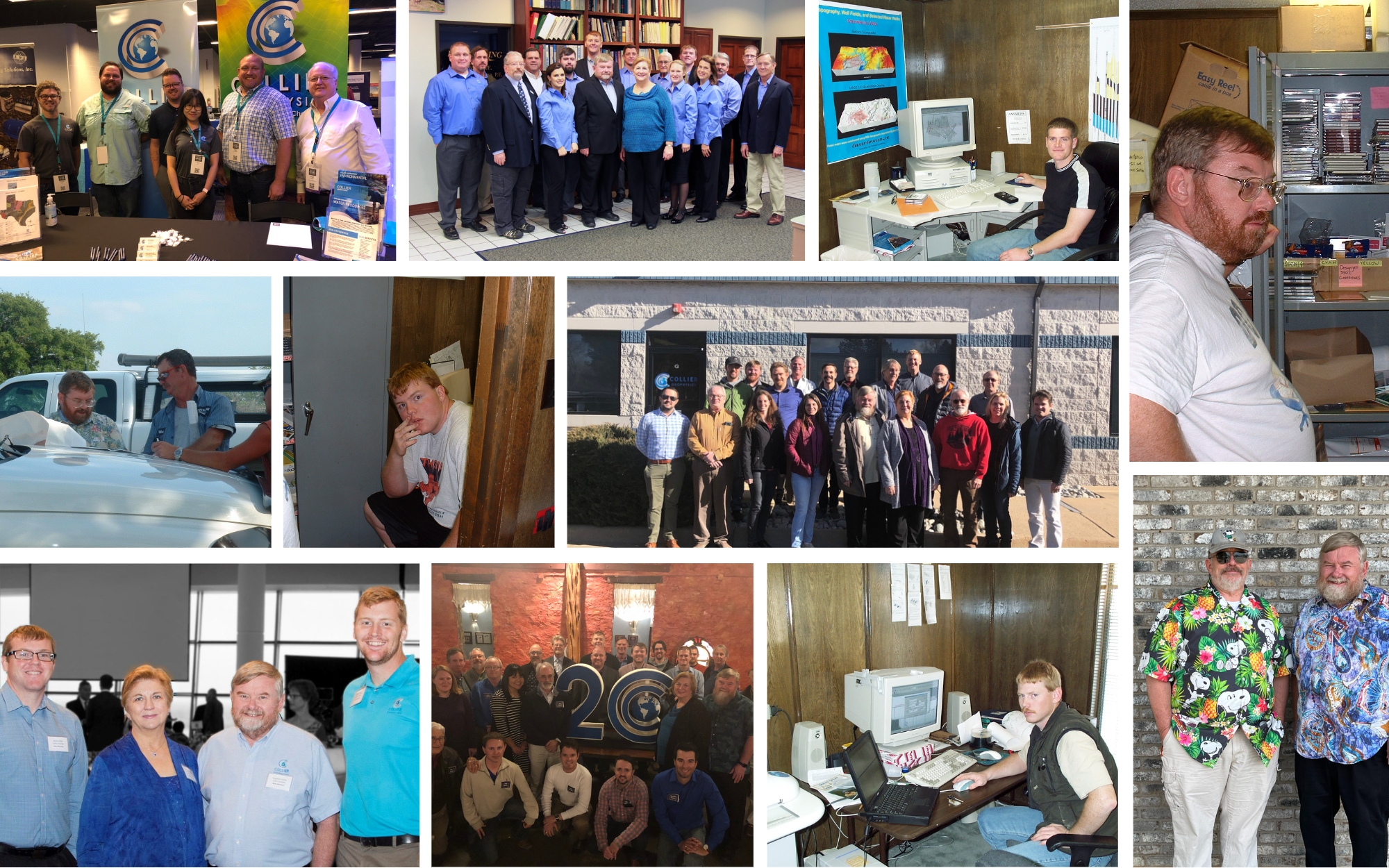
Looking back on 25 years – Collier Consulting is thankful to be celebrating our 25th anniversary! This milestone has been made possible because of the clients we have had the privilege to serve and the outstanding, dedicated scientists and engineers who have been part of the Collier Consulting family. Our firm incorporated in 1998, but its roots go back another 25 years – to graduate schools at Mississippi State and UT Dallas, teaching tenures at Abilene Christian University and Tarleton State University, a Texas Water Development Board research project, and work experience as a petroleum geologist in Abilene, Texas. Honestly, Gail and I never started out to have a consulting company; it was the furthest thing from our minds. Our goal was to continue teaching at a university and consulting part-time, but opportunities and challenges opened the door for full-time consulting. What started out as “offices” in the corner of our kitchen has evolved to where we are today. All of this has only been possible because of the trust, support, and mentorship of so many clients, associates, friends, and family. We are extremely thankful to God for His blessings and for all of you! We are grateful for the opportunities afforded to us over the past 25 years and look forward to opportunities that are on the horizon. We are excited for and confident in how the next generation of the Collier Consulting family will continue to serve!
– Hughbert & Gail Collier
Collier Geophysics (Collier) is pleased to announce the acquisition of New England based Hager GeoScience (HGI). HGI has provided exceptional consulting services in geology and geophysics throughout the United States and internationally for over 29 years. We would like to recognize owners Jutta Hager and Mario Carnevale for building such an amazing company. We are honored that HGI has entrusted Collier to take over their legacy and carry it forward into the next generation.
Through the addition of HGI, Collier has expanded its national presence into the Northeast. The merger of these two companies is a vital step in Collier’s mission to provide nationwide geoscience and geophysical services. Jutta and Mario will continue to lead the HGI office and provide the same high-quality service to their clients. HGI will also now be able to offer expanded surface, borehole, marine, and airborne geophysical services through Collier’s national network.
Collier is excited to continue building a nation-wide company that is centered on professionalism, exceptional science, a team-focused environment, and top-notch customer service.
![]()
Collier Geophysics (Collier) and Aqua Geo Frameworks, LLC (AGF) are excited to announce a strategic alliance between our companies. This alliance allows a formal collaboration between Collier’s surface, borehole, and marine geophysical expertise and AGF’s airborne electromagnetic (AEM) investigations. This alliance provides for an industry leading set of expertise between the two organizations. Over the years, the large-scale AEM projects have needed fill-in and ground-based geophysical surveys to provide clients with a complete geologic framework for their project needs.
The experience brought together by Collier and AGF staff offers tremendous breadth and depth from geologists, hydrologists, geophysicists and engineers to solve complex hydrologic and geologic problems. Additionally, the scale-factor to acquire townships worth of data with AEM, follow-up with the mobile Wallaby TEM array, or any other variety of geophysical methods, gives this alliance an edge to working at any level of project size desired.
With the ever-increasing demand for water resources, we believe this alliance will give federal, state, city and water district managers the value to select how and why particular methods are applied for their projects. This team provides a powerful combination of AEM and ground-based geophysical surveys including exploration for water resources, aquifer characterization, managed aquifer recharge, and environmental site characterization. With both Collier and AGF’s broad experience across the world, our alliance brings both our clients a collective team with unparalleled skill and experience.
Collier is excited to announce the opening of our new office in Atlanta, Georgia. We are please to welcome Jorgen Bergstrom, P.Gp. to the team as our out Atlanta Operations Manager! Mr. Bergstrom has over 25 years’ experience in geophysical methods and instruments in the United States and Europe. During his career, he has conducted numerous geophysical investigations assisting clients with subsurface characterization. These investigations have involved using geophysical methods such as ground penetrating radar (GPR), borehole and surface radar tomography (RT), resistivity, seismic, magnetic, electromagnetic, and acoustic. Mr. Bergstrom also provides geophysical borehole logging services, for a number of applications, to assist clients determine structure, fracture orientations, and fluid flow in rock. He has authored numerous publications discussing various geophysical technologies.
Mr. Bergstrom is involved in the Environmental and Engineering Geophysical Society and the Society of American Military Engineers. Welcome to the team Jorgen!
Jorgen can be reached at:
Office: (254) 968-8741
Cell: (770) 543-8444