April 7, 2025
Picture of the month prepared by Andrew Stone, Hydrogeologist, (andrewstone @ gmail.com)
In the old days, geology surveys were carried out slowly and laboriously via the “soles of geologists’ boots.” Times and technology have changed. Adapting land-based methods, airborne geophysical exploration to map geology and hydrogeology has now gained rapid worldwide acceptance.
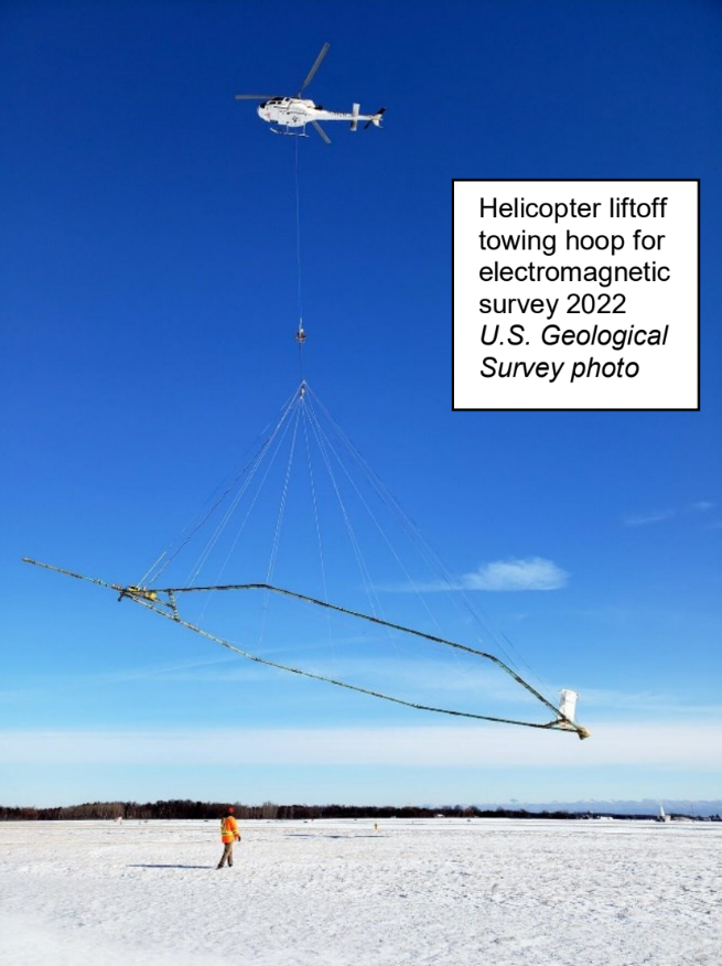
The photograph shows a helicopter carrying an airborne electromagnetic induction sensor over northeastern Wisconsin as part of a 2022 study to map aquifers. Data from the survey were used to create and refine models of water availability for Wisconsin’s resource managers and policy makers. The project was a collaboration by the U.S. Geological Survey and several Wisconsin state agencies.
By digitally mapping the subsurface from the air, airborne geophysical surveys by drone, helicopter or plane can rapidly provide high-resolution comprehensive subsurface information for geological, geotechnical and hydrogeological applications. Airborne survey data can be collected without ecological disturbance, disrupting agriculture or negotiating access to private land. Additional benefits result from access to inhospitable terrain and avoiding the logistics of adverse weather conditions for ground crews.
In 1855, back in the mid-19th century, Gaspar Tournachon patented the idea of aerial photographs for surveying. Early photography from hot air balloons showed the benefits of a “birds eye view” perspective of the earth. First adopted for mapping and military intelligence, use of an “eye in the sky "photography had many applications from the mid-19th to the mid-20th century.
Airborne geophysical surveys (mostly for oil and mineral exploration) began 70+ years ago after the Second World War and became “routine” in the late 60’s with increasing technological innovations for surveys of the electrical properties of the earth. In selecting the line of direction to fly surveys, operators need to account for direction of the Earth’s magnetic field in the target area and the orientation of known geological features related to the survey’s objectives. Airborne instruments are typically more sensitive than ground-based geophysics equipment because of the increased distance of the airborne signal from the land surface and subsurface under investigation.
Airborne geophysics digital data collection has huge time-saving cost benefits. By calibrating (ground truthing) airborne spatial data to existing borehole logs and geological maps, experts can identify groundwater aquifers, zones of water pollution or high groundwater salinity, determine how geology influences an aquifer’s three-dimensional geometry, select favorable areas for additional land-based assessment and select drilling sites to optimize the chances of successful wells.
Modern airborne geophysical surveys with various transmitters and receivers typically measure Earth’s magnetic field, naturally occurring gamma radiation and electrical conductivity. In addition, the tennis court-size platform arrays carried by helicopters, as shown in the USGS photograph, will probably also carry altimeters, video cameras and global positioning equipment.
Airborne geophysics surveys of the ground and subsurface are now one of the main tools in the geologists’ and hydrogeologists’ toolbox. With demographic pressures, changing weather patterns, and finite (although potentially renewable) water resources, accurate scientific resource assessments are crucial as the basis for water management decisions and the political prioritization of water allocation at local regional, national and global scale.
More information:
Wisconsin Survey (4 minute video): Southern Wisconsin Airborne Electromagnetic Survey 2022 | U.S. Geological Survey
Gaspar Tournachon: History of Aerial Photography
Airborne Geophysics:
https://colliergeophysics.com/airborne-geophysics/
https://csegrecorder.com/articles/view/the-application-of-airborne-geophysics-for-water-exploration
https://www.bing.com/videos/riverview/relatedvideo?q=+airborne+geophysics+for+groundwater+applications&mid=511DED9A46ACDCD923C5511DED9A46ACDCD923C5&FORM=VIRE