April 8, 2026
Fresh Groundwater Aquifers Under the Sea?
Yes! And there’s lots of it that could be pumped for water supply use on land
Prepared by Andrew Stone, Hydrogeologist (andrewstonewater(at)gmail.com)
An international team of scientists, led by Dr. Brandon Dugan, Hydrologic Science and Engineering Program, Colorado School of Mines, has been researching below the seabed for places where there are geological layers saturated with fresh water! To the right of this page is the logo of the research team, “Expedition 501 New England Shelf Hydrogeology.” The expedition is a joint collaboration between the International Ocean Drilling Programme and the US National Science Foundation. The work of the scientists is to find out where freshwater occurs offshore, quantify how much there is, work out when it got there and then (perhaps) work with coastal water managers to determine if there is an economical way to pump the freshwater onshore for water supply. This project is an exciting groundwater resources research endeavor encompassing the latest science and technology. Updates of all aspects of the project are reported online and should be of broad interest to all water managers and groundwater professionals.
At many places worldwide the locations of coastal submarine freshwater springs close to shore have been known for centuries. For these springs, the source of the freshwater bubbling up from the seabed is from aquifers recharged on land. However, the groundwater that is the focus of the Shelf Hydrology Project is too far offshore to be linked to any current land-sourced supply. The 501 research is building on previous studies, including geophysics surveys, and is focused on mapping the characteristics, dimensions and geometry of the fresh water in offshore aquifers and in determining the mechanisms by which freshwater came to be in continental shelf submarine aquifers.
During the Pleistocene ice ages, sea levels were at times over 300 feet lower than now. The continental shelf was then dry land, and aquifers could have been recharged by precipitation. Perhaps the shelf aquifers were recharged more recently with fresh meltwater under pressure beneath the ice during periods of glacial advances of ice sheets. Expedition 501 research may provide definitive answers.
Drilling in the 1970s provided evidence of freshwater in sediment layers below the New England shelf seabed. An exploratory borehole was drilled over 1,500 feet deep on Nantucket Island, Massachusetts in 1978, as part of the U.S. Geological Survey’s Stratigraphic Test Well project. This well found fresh water in in Pliocene-Pleistocene sand aquifers. In places the groundwater was less than 1,000 mg/L (seawater is 35,000 mg/L). The lenses of relatively fresh groundwater occurred in coarse grained sediments. The groundwater in layers of fine-grained silts and clays had higher salinities. An 850 ft exploration well drilled near Edgartown on Martha’s Vineyard Island in the late 1970s also showed groundwater of varying quality, with freshwater at 475 feet below sea level.
In 2025, Expedition 501 drilled a transect of three wells south of Nantucket. These were drilled from a lift boat through the shelf seabed to depths of 1,500 feet. Detailed logs of the geological layers and the chemistry of the groundwater were obtained during drilling. Over 2,500 feet of sediment cores were recovered for more detailed laboratory work on the hydraulic properties of the sediment, groundwater chemistry, microbiology and noble gas measurements. The cores are now stored at the Center for Marine Environmental Sciences at the University of Bremen (Germany) and all expedition data will be open access. The research results may have application that will assist assessment of the Earth’s many ocean shelf submarine aquifers with potential value as supply sources.
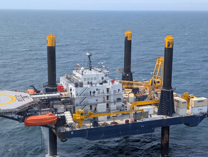
The 180 ft. long lift boat Robert is a self-elevating service vessel. Once in place, the boat is jacked up about 30 feet above high tide level and becomes a drilling platform. photo:
Mowat@ECORD_IODP3_NSFInformation for this Groundwater Picture of the Month was obtained from several internet sources.
Detailed information about offshore groundwater can be reached by browsing Expedition 501 New England Shelf Hydrogeology.
https://www.ecord.org/expedition501/ is the good initial source.